Africa is currently undergoing rapid urban expansion. According to the 2020 Africapolis report, Africa’s urban population has increased from 27 million in 1950 to 567 million in 2015, with further rapid growth projected to continue.
The consequences of this rapid growth on the distribution of armed conflict in Africa remain under-studied, despite being crucial for the political stability of the continent. Will urbanization lead to an increase in violent events in urban areas? Or will rural areas be increasingly affected by political violence?
Consistent definitions of urban spaces are a first step towards answering these questions. The Africapolis project led by the OECD offers an effective solution to this problem, by providing geospatial data on urban spaces across Africa from the 1950s to 2015.
Unlike other databases that rely on national definitions of cities, Africapolis is a standardized database on cities and urbanization dynamics in Africa that allows scientists and policy-makers to study long-term perspectives for the entire African continent.
The objective of this blog is to further advance these efforts, by providing a tool that can automatically check whether a violent event takes place within an urban or rural area.
The Urban Africa Labelling (URBAL) tool provides an efficient method of classifying data points available in the Africapolis database using the latitude and longitude of the location of any violent event. The source code can be found in this Github repository.
URBAL can be used alongside the Armed Conflict Location and Event Data project (ACLED) database to map how the number of violent events in urban spaces has changed in proportion to those in rural spaces at the country level.
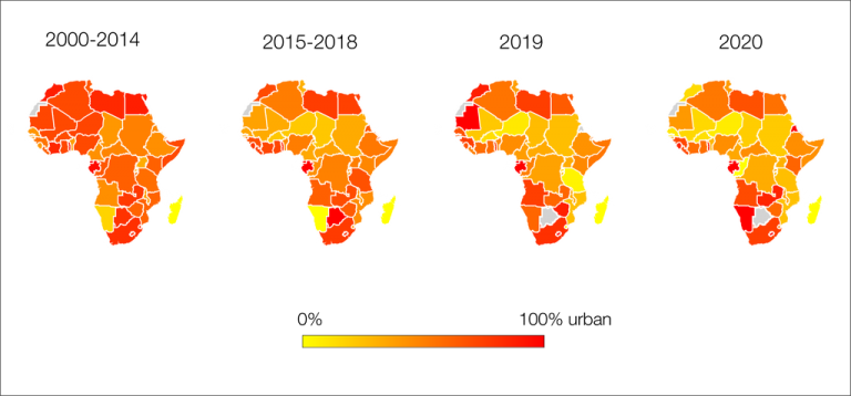
The following figures suggest that violent events have increasingly moved to rural areas in West and Central Africa, particularly in the last five years. In Southern Africa, however, a vast majority of violent events still take place in urban areas.
Map 1. Proportion of violent events located in urban areas by country, 2000-2020

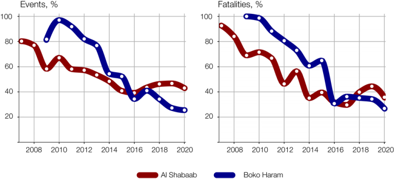
The URBAL tool can also be used to study how the patterns of attacks of specific extremist groups such as Al Shabaab in the Horn of Africa and Boko Haram in West Africa have changed over time (Figure 1).
For both groups, the percentage of events and fatalities occurring in urban areas have dramatically decreased over the years despite the rapid population growth of cities in Somalia and northern Nigeria.
While Al Shabaab and Boko Haram were predominantly active in cities until the early 2010s, both groups have reorganized into rural guerrilla forces following the counter-offensive of the African Union Mission (AMISOM) in Somalia and the Nigeria-led Multinational Joint Task Force (MNJTF) around Lake Chad.
Figure 1. Violent events and fatalities located in urban areas by group, 2008-2020

Understanding how politically-motivated violence spreads across space is crucial to assess risks and respond to threats that can destabilize central governments. Counter-terrorist strategies developed to fight extremist groups in urban areas are largely ineffective in rural regions, for example.
Any statistical model used in the evaluation of risk must therefore differentiate between urban and rural areas effectively. By offering an effective method of identifying locations as urban or rural, the URBAL tool can help these models and contribute to a more spatial approach to conflicts in Africa.
By Ewan Davies, University of Oxford
