As ECOWAS prepares for a military intervention, a conflict between Niger and Nigeria could threaten the deep social and economic ties developed on both sides of the border.
Hausaland divided
‘The people of Niger Republic are one and the same with those living in Northern Nigeria’, wrote former Kaduna State Governor Nasiru Ahmed El-Rufai recently. This has not always been the case. For many centuries, the vast region stretching across the modern Niger-Nigeria border known as Hausaland was divided between numerous states organized around fortified towns. “Hausa polities exhibited more rivalry than unity” notes Bill Miles, suggesting a certain level of hostility between states for the control of regional trade routes.
The creation of the Sokoto Caliphate by the Fulani in 1804 hardly led to the unification of the entire region. Political leaders left the states of Gobir, Katsina and Daura to establish new political entities in the north, from which they hoped to reconquer lost territories and regain control of trade, notes Camille Lefebvre. Wars between the Caliphate and its peripheries led to the creation of a “frontier of separation” that extended from Kebbi in the west to Bornu in the east. As noted by Anthony Asiwaju in Bridging African Boundaries, this vast frontier region did not take the form of a fixed political border until colonization.
“All that fairly belongs to Sokoto”
Colonization initially contributed to accentuate existing disparities across the region. Unlike in other regions of Africa where borders disregarded ethnic frontiers, much “consideration was given to the indigenous political organization” when the colonial border was drawn between the British and the French. The Anglo-French declaration of 1890 stated that the British sphere of action would include “all that fairly belongs to the Kingdom of Sokoto”, with which the Royal Niger Company had signed a treaty. Of course, as Paul Nugent explains, “the insertion of this clause greatly muddied the waters because the extent of the domains of Sokoto was open to very different interpretations”.
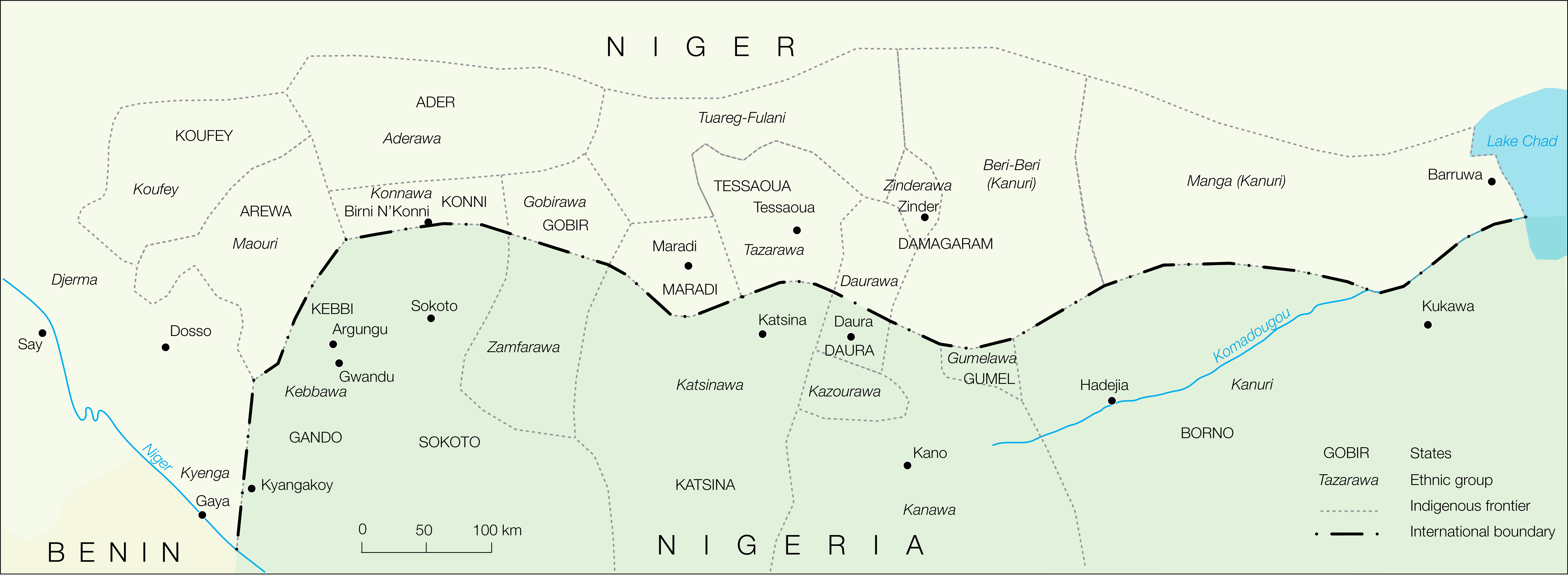
After 16 years of negotiation, the colonial powers agreed that the Hausa states that were permanently incorporated into the Sokoto Caliphate, such as Sokoto, Zamfara and Katsina would become part of the British empire. Those that resisted the Fulani hegemony or were subject to other kingdoms would become French, such as Gobir, Tessaoua, Maradi and Damagaram (Map 1). “North of the boundary were the exiled Habe [pre-Islamic Hausa elite] states that remained independent of the Fulani Sokoto Empire” explains Thom, “whereas south of the boundary were the states that succumbed to the Fulani Jihad”.
Map 1. Indigenous and international boundaries between Niger and Nigeria

Source: adapted from Prescott (1971) and Thom (1975) by the author. Note: The international boundary between Niger and Nigeria was adopted following the Anglo-French Treaty of 1906 and demarcated between 1906 and 1908. Indigenous boundaries are represented as in the early 20th century.
The rise of cross-border trade
In the first half of the 20th century, the colonial partition between France and Great Britain had the paradoxical consequence of reinforcing the homogeneity of Hausaland, due to intense population and economic exchanges. Thousands of migrants from French-controlled territory resettled in the frontier areas that had been depopulated in the 19th century. Because so many people moved in such a short period of time, “ethnic boundaries no longer conform with the international boundary” between the two countries.
Colonization also contributed to foster economic integration on both sides of the border on an unprecedented scale. New markets were created within the former frontier areas to benefit from the new resources offered by the colonial partition, such as Jibia, in today’s Nigeria. As Paul Nugent and Anthony Asiwaju explain, border populations quickly exploited “the opportunities for cross-border trade which were created by the existence of different colonial systems”.
A highly integrated region
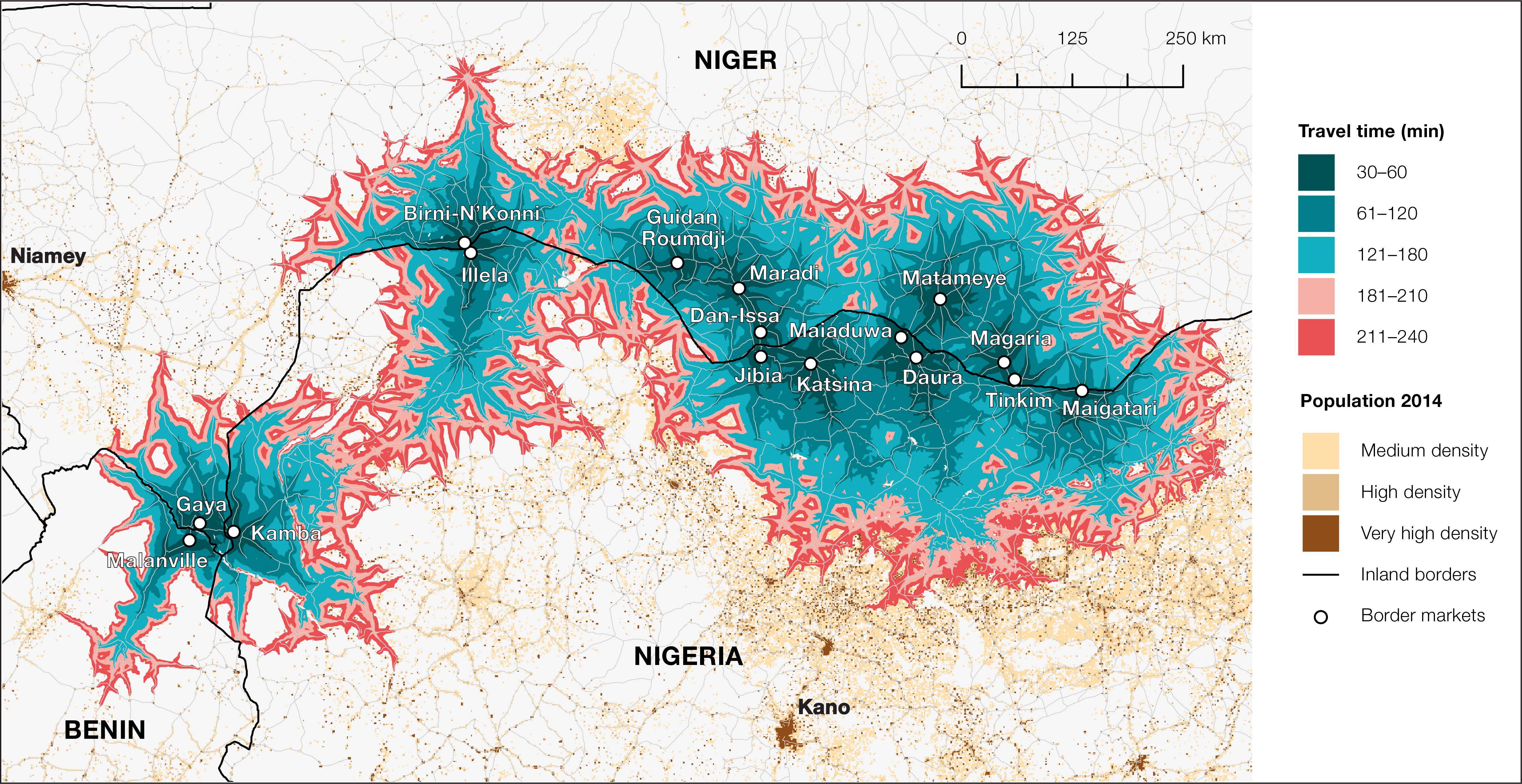
Informal integration between southern Niger and northern Nigeria greatly accelerated in the postcolonial era. Today, the borderlands between the two countries are functionally integrated through 16 large border markets that form a contiguous market area, from Gaya in the west to Maigatari in the east (Map 2).
Map 2. Border markets and population potential along the Niger-Nigeria border

Source: OECD/SWAC (2017), modified by the author with permission. The population potential represents the market area that is accessible from a border market in less than four hours using the local transportation network.
The growth of these markets is fueled by differences in tax policies, subsidies harmonization, and bans affecting imports and exports. Far from being limited to border regions, trade networks established in Hausaland connect most major cities across West Africa to the world markets. Agricultural and manufactured products found in Kamba, Illela, Dan Issa or Magaria have often traveled from the Middle East, Europe and South Asia, before reaching their final destination.
Borderlands are actively exploited by a new generation of entrepreneurs attracted by the economic potentialities of border markets. In southern Niger, for example, the development of second-hand textile trade relies on the existence of a trading diaspora with sufficient capital and experience to take advantage of the border situation.
Regional integration at risk
A military conflict between Niger and ECOWAS would deal a severe blow to the social and economic networks built across the border over the last decades. The stakes are particularly high for Niger, a landlocked country for whom Nigeria is both the largest import and export market. As in the past, a prolonged border closure accompanied by an open conflict would have devastating consequences on borderlanders’ livelihoods, traders’ activities and millions of West Africans who depends on informal trade across the region.
A military intervention would also put an end to the various initiatives implemented over the last decades to promote cross-border cooperation in the region, such as the Nigeria-Niger Joint Commission for Cooperation, ECOWAS Cross-Border Initiatives Programme, or the Niamey Convention adopted by the African Union in 2014. In a region where roads are sparse and poorly maintained, a military intervention would also put a stop to the development of large infrastructure projects that promote cross-border accessibility, such as the Kano-Maradi railway.
As Anthony Asiwaju recently noted, diplomacy should prevail in Hausaland, to preserve the numerous cross-border commonalities shared by Niger and Nigeria, and avoid opening up new fault lines within what is one of the most remarkably integrated regions in West Africa.
By Olivier Walther. 9/4/2023
Acknowledgements: the author thanks Moustapha Koné, Paul Nugent, Bill Miles, Matthew Pflaum, and Leonardo Villalón and for their comments. Any errors are my sole responsibility.
