

Conflict in West Africa is shaped by a struggle between mobile insurgents and states whose power depends on territorial control. While insurgents exploit speed and rural fluidity to expand their reach, states retreat into fortified towns and military enclaves. Mobile space theory can help explain this recurring spatial pattern.
By Olivier Walther, 5/6/2026.
The fortification of West Africa
Over the past 15 years, West Africa has gradually become dotted with trenches designed to protect cities from jihadist incursions. These new fortresses have created an archipelago of government-controlled zones, surrounded by vast rural areas where insurgents move relatively freely.
In northeastern Nigeria, where these fortified enclaves first developed in the 2010s, more than 700 kilometers of trenches have been dug by the government, international donors, and local communities. Mali, Niger, Cameroon, Chad, and Burkina Faso have since undertaken similar projects.
The construction of these trenches follows a very specific pattern. First, security forces come under attack from all sides by armed groups on motorcycles. Then they fortify their positions and the nearby settlements with defensive trenches. Finally, when trenches are breached, the military retreats to more heavily fortified camps.
Trench-digging begins when it becomes impossible to control the movements of armed groups. By restricting or prohibiting access to towns, security forces are responding to a dynamic initiated by their adversaries. While the insurgents’ strength lies in their ability to be potentially everywhere, the government’s main resource is its capacity to control territories bounded by fixed borders.
The resurgence of fortifications in West Africa presents an opportunity to reexamine the tension between mobility and territorial control in a way that enriches geographical theory. To explain this recurring pattern, I propose drawing on mobile space theory, which was originally developed by French geographer Denis Retaillé.
A mobile idea of space
Fundamentally relational, mobile space theory argues that geographical space is a phenomenon, rather than a medium or a milieu, which is constantly subject to change. This change is conceived as a ‘movement’ that drives human activities.
As Denis Retaillé wrote, “Movement is no longer a displacement, a crisis, but the possibility of a permanent production of space and places”. In this respect, mobile space theory differs from most theories in geography, particularly spatial analysis, which considers movement to be a consequence of the relationships between fixed places.
A mobile approach, I argue, is better suited to grasping the complexity of contemporary conflicts in West Africa than the territorial approach that dominates the literature. Instead of assuming that movement occurs between cities or countries, I examine the forms that movement can take and, only then, how it can lead to the production of geographical space.
In theory, the vast diversity of human movements observed across the Earth’s surface can be reduced to three basic forms: divergence, convergence, or intersection, as presented below.

Divergence occurs when human flows move away from one another, as when farmers expand their crops around their village. Convergence occurs when flows draw closer to one another, like two armies preparing to face each other on the battleground. Finally, intersection occurs at the points where flows cross, as when travelers stop for the night at the same inn.
Each of these forms of movement produces a different type of limit. Divergence forms confines, that is, boundaries that have only one side, the interior one. Convergence creates borders in the sense we use to describe international boundaries. Intersection creates horizons, that is, limits that can be constantly pushed back, like the networks that connect us on the internet.
Mobile space theory also argues that each of these forms of movement and limits is associated with a very concrete geographical object: the frontier is the concrete manifestation of divergence, territory is ultimately bounded by borders, and places are where intersection occurs.
Mobilities in peacetime
West African spaces are deeply shaped by these processes, even in peacetime. To illustrate this, I present a theoretical sequence of events that starts with the creation of frontiers and ends with the emergence of places. For the sake of simplicity, I only consider three types of actors: civilians, insurgents who haven’t yet resorted to violence, and states.
Where space is unlimited, these actors are free to move without constraints and in any direction. This creates new frontiers, as shown in the upper part of the figure below. Herders move to new pastures. Farmers expand their fields, asserting their land rights against anyone who might want to settle in the area in the future.

Insurgent groups that aim at overthrowing the central government also produce frontiers by spreading to remote regions. In the early 2000s, for example, the radical Islamists of what would become Boko Haram established a commune in the extreme north of Yobe State, many years before their violent uprising in Maiduguri.
States try by every means possible to push back these frontiers, projecting their authority as far as they can. They hardly have the choice. There can be no sovereignty as long as they do not have exclusive and exhaustive control over “their” national territory.
Over time, these frontiers expand until they eventually solidify as hard borders. Convergence gives rise to territory. Pastoralists encounter cultivated lands. Farmers have no more land to clear. Would-be insurgents encounter rival groups. States push hard against the border line, by digging long border trench lines, as in Cameroon and Togo today.
This process produces tensions long before armed conflicts break out. In Mali, Dogon farmers started migrating from their hilltop villages into the plains that were once the exclusive domain of Fulani herders after decolonization. Further north, jihadists expelled from Algeria expanded their alliances among local tribes many years before the war broke out in 2012.
The process of border consolidation is accompanied by the emergence of settlements of all sizes, as indicated in the lower part of the above figure. Villages, towns and cities emerge where civilians build a mosque or a market. Insurgents create training camps in the bush, weapon caches, and temporary markets to sell stolen cattle and buy Chinese motorcycles.
States produce central places, too, foremost among them the capital, where political power is concentrated, but also numerous military bases, from which they hope to prevent the outbreak of hostilities.
Mobilities in wartime
The outbreak of an armed conflict produces new kinds of material spaces. War is the most extreme form of movement, at the end of which cities, borders, and territories are destroyed, displaced, or reinvented.
At the same time, war also brings to a head tensions that have had time to develop, sometimes over decades of peace, as in the Sahel today. To account for this continuity, I pick up my story where I left off and show how space is produced by violence.
As shown in the upper part of the next figure, the places produced by the violent interactions between civilians, on the one hand, and insurgents and state forces, on the other hand, are typical of massacres. After more than 15 years of armed conflict, the West African landscape is now dotted with these places of grim remembrance, as in Nigeria, Burkina Faso, and Mali.
Places created by the violent interactions between state and insurgents are emblematic of battles. Most of these battles take the form of short-lived engagements. The first Battle of Tongo Tongo, during which eight American and Nigerien soldiers were killed by Islamic State militants in 2017, lasted three hours.
For several years now, West African states have been working to fortify these places with defensive trenches. These fortifications serve to protect the troops and to shelter refugees who can no longer live in rural areas.
Once the insurgents control the countryside and the main roads, it becomes increasingly difficult for government forces to move between places, which further reinforces the importance of fortified centers.
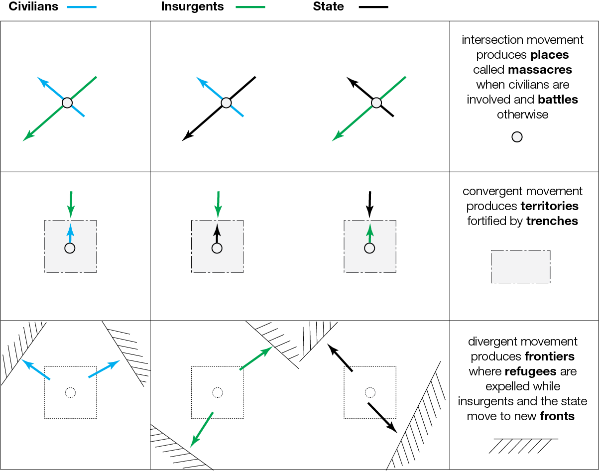
Eventually, some of these fortified places are overrun by insurgents. Trenches and towns disappear. This process creates new frontiers, as shown in the lower part of the above figure. The civilians who have escaped from the attack become refugees. State forces and insurgents move to new areas. The cycle that started in peacetime with the creation of fronts ends with the same material space.
Towards a more “mobile” paradigm
West African conflicts are best understood as a spatial struggle between insurgents who operate through movement, and governments whose sovereignty requires exclusive territorial control. As insurgents gain sway over the countryside, state forces increasingly lose the ability to move freely, reinforcing reliance on fortifications.
Drawing on mobile space theory, I have argued that space in West African conflicts was continuously produced through various forms of movement rather than simply occupied. Peace and war are linked through recurring cycles in which frontiers, borders, and places emerge, harden, and sometimes disappear through violence.
My colleagues and I have started to pay more attention to the temporality and spatiality violence on the African continent. In a paper published last year, we showed that African conflicts go through distinct “spatial conflict life cycles” as they emerge, develop, and eventually end.
More recently, our longitudinal sequence analysis suggests that trajectories of conflict in one location are associated with those of neighboring areas, creating enduring regional complexes of violence. These patterns underscore the importance of analyzing conflict not only as discrete events but as evolving life cycles embedded in wider geographic contexts.
Much remains to be done, though, to produce a relational approach that can explain how armed conflicts develop both spatially and temporally. The biggest challenge is probably our difficulty to fully think of movement as a driving force in the production of geographical space.
We are so influenced by the prevailing “sedentary” paradigm, which holds that violence stems from territorial competition, that we tend to overlook the other spatial forms that human activities take, particularly mobility.
This blog is a contribution to a more “mobile” paradigm. By focusing on various forms of movements, it should offer an alternative framework for explaining why fortified states and mobile insurgents repeatedly reproduce the same unstable landscape across West Africa.